Philippines Quake Redraws Coastline as Massive Uplift Leaves Communities Displaced
Glan – A powerful earthquake that killed at least 76 people in the southern Philippines this month has dramatically altered parts of Mindanao’s coastline, pushing sections of the seabed above water and permanently reshaping communities that depend on fishing and tourism.
The magnitude 7.8 earthquake struck on June 8 near the Cotabato Trench off Mindanao, triggering landslides, damaging infrastructure and causing widespread displacement. Scientists say the quake also generated significant coastal uplift, a geological process in which tectonic forces force sections of land upward.
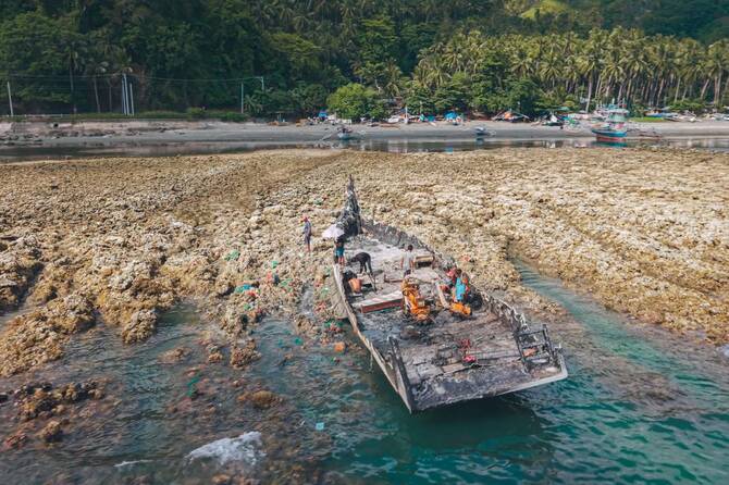
Initial assessments by Philippine seismologists indicate that parts of the seabed rose by as much as two meters, extending the shoreline by up to 200 meters in some areas and transforming previously submerged coral reefs into exposed stretches of land.
“What they see now is their new coastline,” said Nane Danlag of the Philippine seismology agency, adding that the changes are permanent.
The affected zone stretches across nearly 100 kilometers of coastline between communities in southern Mindanao, according to preliminary surveys.
Residents described witnessing the transformation as it unfolded. Arsenio Butil Jr., a fisherman and pastor from Sarangani province’s Glan municipality, said the sea repeatedly receded and returned during the earthquake.
“What I saw at the shoreline was that the water receded. After a while, I saw it slowly returning. And then it receded again. Maybe three or four times,” he said.
The newly elevated coastline has left fishing boats stranded far from the water and exposed large expanses of coral that had previously been underwater.
The geological shift has also heightened anxiety among residents already traumatized by the disaster. In a hillside evacuation site near the coast, around 100 displaced villagers continued to shelter in temporary conditions more than a week after the earthquake.
Many fear that further seismic activity could trigger a tsunami despite reassurances from experts.
“What if the sea surges forward? That is what everyone fears,” said Datu Atom Malimpnig, a local community leader whose village was heavily affected.
The changes are also threatening tourism-dependent businesses. Resort operators along the coast say the exposed coral and shallower waters have altered beachfront landscapes that once attracted visitors.
Edzel Baylon, an employee at the Isla Jardin del Mar resort, said the area’s white-sand beaches are now separated from the sea by broad stretches of uplifted coral.
“It has a huge effect on the resort, because the main draw for customers is the sea,” Baylon said.
Seismologists noted that the Cotabato Trench is among the Philippines’ most active seismic zones. Thousands of smaller tremors were recorded in the area earlier this year, and authorities have logged more than 8,500 aftershocks since the June 8 earthquake.
Scientists say the coastal uplift is part of a natural tectonic process that has shaped the region over thousands of years, although the scale of the changes has been striking for residents witnessing the transformation firsthand.
With aftershocks continuing across the region, many families remain reluctant to rebuild homes damaged by the earthquake, citing concerns about cracked ground and the possibility of further strong tremors.